Showing posts with label Google Maps. Show all posts

Friday, July 9, 2010

Shorter Google Maps URLs

Google Maps URLs are very long because they include a lot of parameters. They're way too long to be added to a Twitter message, a news article or a banner.

To solve this problem, Google Maps Labs added a feature called "short URLs" that shows short permalinks when you click on "Link". The nice thing about this feature is that it uses Google's URL shortening service, which is very fast, and URLs are more descriptive because they include "goo.gl" and "maps".


To get the full permalink, you need to right-click on "Link" and copy the location. Unfortunately, Google removes the embedding feature if you enable "short URLs". Maybe it would make more sense to show the short URL as an additional option.

Monday, June 21, 2010

Distance Measurement in Google Maps Labs

Google Maps Labs added a feature that used to be available as a mapplet: distance measurement tool. After enabling the Labs feature, you'll notice a small ruler at the bottom of the map. Click on the ruler and you'll be able to use the distance measurement tool by clicking on the map and tracing the path you want to measure.


If you click on "I'm feeling geeky", you'll be able to pick from a long list of measurement units, including light-year, parsec, PostScript points, Olympic swimming pools, American footbal fields, Persian cubits and more.

Wednesday, June 9, 2010

Google Maps Navigation for Canada and 10 European Countries

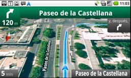
Google Maps Navigation for Android is now available for Canada, Austria, Belgium, Denmark, France, Germany, Italy, the Netherlands, Portugal, Spain, and Switzerland, in addition to the 3 countries that were already supported: US, UK and Ireland. It's interesting to notice that Google still uses data from Tele Atlas for all the countries supported by Google Maps Navigation, except for the US and Canada.


"Google Maps Navigation is an Internet-connected GPS navigation or 'satnav' system that provides turn-by-turn voice guidance as a free feature of Google Maps. Google Maps Navigation (beta) with Search by voice is available in version 4.2 of Google Maps, on Android devices 1.6 and higher," explains Google.

Free turn-by-turn navigation could be an important reason why people choose a mobile phone, so Google and Nokia try to make the most of Google Maps Navigation for Android and Ovi Maps for Symbian. Most likely, in the near future, all smartphones will include a free application for navigation.

In other related news, Google Search by Voice is now available for German, Italian, Spanish and French. Search by voice is an important feature of the Quick Search Box app for Android, Google Mobile App for iPhone and Blackberry. The nice thing is that you don't have to download an update for none of the applications, as the new languages are automatically recognized.

Tuesday, June 8, 2010

Google Maps Previews in Gmail

Gmail added a new Labs feature that parses your messages and lets you preview some content using web services. This time you can preview the addresses from a message using Google Maps. The addresses extracted by Gmail are displayed after a message and you can load a map preview without opening a new page. Right now, the feature only works for US addresses, but Google promises to address this issue.


Gmail already displays addresses from messages in the right sidebar, but you need to click on a link to open the map in a new page. The new Gmail Labs feature has another advantage: it also previews links to Google Maps.

Gmail's blog says that a map preview feature is now available for Google Buzz, but it only works when you paste a Google Maps link in a Buzz message. Unfortunately, Google's thumbnails is really small and clicking on the thumbnail opens a static map.


To find the Labs feature, open Gmail Labs and use your browser's find-on-page feature (Ctrl+F / Cmd-F) to search for "Google Maps previews". Gmail Labs offers other similar contextual gadgets for previewing links to Flickr, Picasa Web, Yelp, Google Voice messages, Google Docs and the YouTube preview feature is enabled by default. Developers can create custom contextual gadgets for Gmail in Google Apps and hopefully the APIs will be extended to the regular Gmail app.

Monday, April 26, 2010

Google Earth Tab in Google Maps

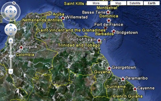
Google Maps replaced the terrain tab with a tab for Google Earth. When you click on the Earth tab, Google asks you to install a plug-in for Windows or Mac. If you have a recent version of Google Earth, you already have the plug-in.

"Five years ago, shortly after Google's acquisition of Keyhole, we introduced the first integration of Keyhole technology into Google Maps -- Satellite view. Suddenly, you could see what places actually looked like from the air, and easily switch between this view and the map view. Mapping has never been the same. A few months later, the desktop Google Earth application was released, and now we have over 600 million downloads. Today we are proud to announce the next major step in the marriage between Google Earth and Google Maps -- Earth view," says Peter Birch, from Google.

Even though the new view makes it easier to use Google Earth, since you no longer have to open a new application, I think it's a bad idea to add it to Google Maps. Google Earth plug-in uses a lot of resources, it slows down your browser and it continues to run in the background even if you switch to the Map tab. What's more, if you open Google Maps in another window and switch to the Earth tab, a new instance of the Google Earth plug-in will load.


{ Thanks, Andrew. }

Thursday, April 22, 2010

Google Maps Adds Kinetic Scrolling

Google Maps has been updated and it now uses kinetic scrolling, a feature inspired by operating systems designed for touch screens. Click on the map, quickly move your mouse and then release it. You'll notice that the map continues to move with the momentum created after you released the mouse.

Now that mobile Google Maps uses the buttons from the desktop interface and both interfaces use kinetic scroll, Google Maps is more consistent.

"Kinetic scrolling is the popular term to denote the scrolling of a long list with a bit of physics so that user feels like moving a wheel. Such a list view is then often referred as a flick list, caused the scrolling involves some sort of flicking gestures. Made popular in iPhone, flick list quickly invades other mobile platforms with touch screen because it just feels so natural and more usable than using the conventional approach of scroll bars," explains Ariya Hidayat.


{ Thanks, que. }

Wednesday, April 21, 2010

More Suggestions in Google Maps

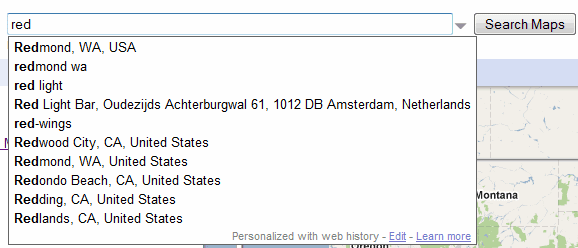
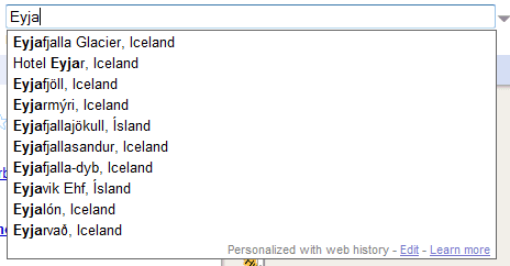
Google Maps no longer shows suggestions only from your recent searches. When you start typing a query, Google Maps shows popular locations, searches and local businesses. For example, you can type "red" and the first suggestion is "Redmond, WA, USA".


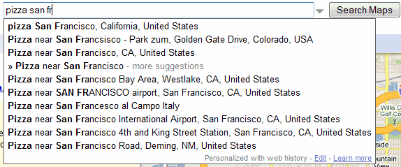
The suggestions are helpful if you want to type a complicated name like Eyjafjallajökull and you only remember the first letters, but Google doesn't do a great job at ranking the list of suggestions.


The autocomplete feature from Google Maps is the first implementation of Google Suggest that uses HTTPS. Google Maps continues to show personalized suggestions from Google Web History, a feature that has replaced Saved Locations.

Google Buzz Layer for Google Maps

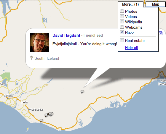
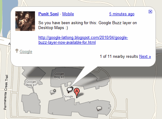
The desktop version of Google Maps added a layer that was already available in the mobile interface: a Google Buzz layer. In addition to showing geotagged Google Buzz messages on the map, Google also shows posts from Twitter, FriendFeed and other similar services, so it's strange to see that the layer is called "Buzz". To enable the layer, go to Google Maps, click on the "More" tab and select "Buzz" from the list of layers.

"Find an interesting area like your neighborhood and select any available icon to see what's going on there. In the post's window, click on the name to see the author's public profile, the timestamp to comment on the post, or the place to see it in Maps," suggests Google.

The integration of Google Buzz's mobile app with Google Maps is probably the best feature of the application. When you post a message using the mobile application, Google uses your location to find nearby places and lets you pick one of them. This way, Google Buzz users can post useful information about local businesses without adding a review to Google Maps.


Google Maps Navigation for the UK and Ireland

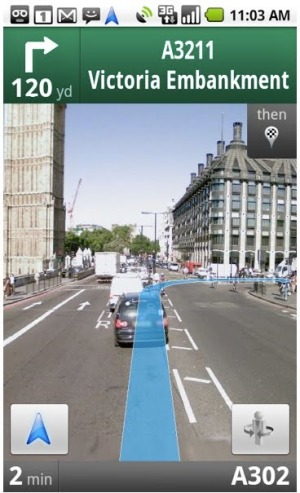
Google Maps Navigation, the Android application that offers turn-by-turn directions for free, is now available for the UK and Ireland. "Like other satnav devices, Navigation includes 3D views, turn-by-turn voice guidance, and automatic rerouting. But because Google Maps Navigation is connected to the Internet, it also features powerful functionality you can't get from other satnav services, including the most up to date map, business, and traffic data, access to satellite and street views, and of course, search," explains Google.

Google's application could add all the countries available in Google Maps, but the licensing terms don't allow Google to show satellite imagery or driving directions in a real-time navigation application. Last year, Google started to use its own mapping data in the US and it's likely that it will do the same for other countries.

Until Google adds more countries to the application, a developer managed to create Google Maps Brut, a modified version of Google Maps Navigation that supports most countries. Even if Google Maps Brut breaks Google's terms, you can try it by installing Nav Launhcer from the Android Market.


Google Maps Navigation requires Android OS 1.6+ and comes included as a part of Google Maps for Android v3.2 and higher. To update the software, Google suggests to search for [Google Maps] in the Android Market.

Tuesday, April 20, 2010

Google Maps Mixes Search Results with Ads

Google Maps has a new feature for business owners in the US: "for just $25 per month, businesses in select cities can make their listings stand out on Google.com and Google Maps with Tags". Google allows businesses to add yellow markers on the map and to promote their websites.

The new Google Maps ads don't influence ranking, but they make some of the results more visible. "Tags do not affect the rank of search results; they simply add more information when a particular user is searching," explains Google.


Until now, Google Maps ads were clearly separated from the organic search results, just like the ads from Google's web search results pages. For only $25 a month, local businesses can now customize their snippets and add a distinctive marker on the map. This features makes the distinction from search results and ads blurrier.

Google doesn't allow publishers to pay for advanced features like customizing snippets, adding rich snippets, showing thumbnails or favicons next to search results. "Google doesn't accept payment to crawl a site more frequently, and we keep the search side of our business separate from our revenue-generating AdWords service," mentions an article from Google's help center for webmasters.

In other related news, Google Local Business Center is now known as Google Places and businesses from US, Japan and Australia can apply for a Google photo shoot. "Google's photographers are specially trained to take great photos of building interiors, dealing with some of the challenges such as low lighting and tight spaces. The photographers are also trained to take panoramic pictures using fisheye and wide angle lenses that should translate into great looking pictures of your business."

Wednesday, April 14, 2010

Google Chat Enhances Links to Google Maps

When you type a link to Google Maps search results in Gmail Chat, iGoogle Chat or orkut's chat box, Google replaces the long URL with the Google Maps query. Google Maps URLs are usually very long because they include a lot of parameters, but Google should do a better job at removing extraneous parameters.


"On the Gmail version of Google Talk, Google now shortens the links and makes them readable. For example, it changes the link: http://maps.google.com/maps?f=q&source=s_q&hl=en&geocode=&q=HEB+near+college+station,+tx&sll=30.606817,-96.309929&sspn=0.050086,0.090895&ie=UTF8&hq=HEB&hnear=College+Station,+TX&ll=30.6128,-96.318512&spn=0.050083,0.090895&z=14 to a link where the text is HEB near College Station, TX," noticed Korben, a reader of this blog.

{ Thanks, Korben. }

Wednesday, March 10, 2010

Google Maps Adds Biking Directions

Google Maps added a new type of directions for the US: bicycling directions. Google's blog explains that "biking directions keep you on bike-friendly roads and avoid some of the city's busiest intersections".


Adding bicycling directions wasn't an easy task because Google had to gather information about bike trails, bike lanes, uphill or downhill slopes. Google's algorithms try to find the best route and they take into account a lot of interesting factors.

"Our biking directions are based on a physical model of the amount of power your body has to exert given the slope of the road you're biking on. Assuming typical values for mass and for wind resistance, we compute the effort you'll require and the speed you'll achieve while going uphill. We take this speed into account when determining the time estimate for your journey, and we also try hard to avoid routes that will require an unreasonable degree of exertion."

Thursday, February 18, 2010

Tag Clouds for Google Maps Photo Layer

Google Maps has a photo layer that shows high-quality images from Panoramio. Finding photos from almost any place in the world makes Google Maps more useful, but sometimes there are too many photos to choose from.

Now you can filter the photos displayed by Google Maps using the tag cloud generated by Google or using your own query. Restrict the photos to panoramas, landscapes, nature or buildings to create a custom photo layer.

Jonah Jones says that this is not the only improvement: "the photos now appear in piles when there are lots of views of the same scene". That means Google groups related images, so that they don't clutter the map.

Friday, February 12, 2010

Google Maps Labs

When a product doesn't have many users, it's easy to add new features, even if they're still experimental. But how can you test new features in popular services like Gmail, Google Docs or Blogger? One solution is to launch a labs section with experimental features that can be enabled by early adopters.

Google Maps is the latest Google service that adds a labs section with cool features that aren't ready for prime time. As Google says, the features "may change, break or disappear at any time".

The most interesting feature available in Gmail Maps Labs is aerial imagery, which shows a "rotatable, high-resolution overhead imagery presented in a new perspective". Unfortunately, the aerial view is only available in a few locations from the US, including Googleplex.


"This new perspective gives users the ability to tilt their view of the world. In addition to seeing hotel rooftops like in our current "satellite" view, users can now see both the rooftop and sides of the hotel at an angle. In fact, users can rotate around all the sides of a hotel to get 4 different views from back to front," explained Google in a post from December.

Another great feature is drag&zoom, which lets you select a part of the map before zooming. This way, the results are more precise and if you don't have to constantly click on the map to find a location.


Did you know that you can search for * and Google Maps shows the top results from the current view? If you don't want to remember this trick, enable the "What's around here" option and Google Maps will add a new button that searches for *.

If you want to find the latitude and longitude of a point using Google Maps, enable "LatLng Marker", right click on a location and select "Drop LatLng Marker". If you use this feature a lot, you should enable a more advanced option that shows the latitude and longitude in a tooltip.


{ Thanks, Pascal. }

Friday, January 8, 2010

Google's Mobile Homepage Shows Nearby Places

Google's mobile homepage for iPhone and Android phones added a cool feature that shows a list of points of interest near you. The page can already find your location, so you only need to click on a category or to select "Explore right here".

"First, we wanted to make it fast and easy to find out more about a place in your immediate vicinity, whether you're standing right in front of a business or if it's just a short walk away. (...) Second, we wanted to make searching for popular categories of nearby places really simple," explains Google.


This is a good example of "queryless" search. Google can provide a list of relevant results just by knowing your location.

Apparently, this feature is available in the US for iPhone OS 3.0+ and Android 2.0.1+, but I managed to enable it outside of US by setting the region format to "United States" and by updating the location.

Wednesday, December 23, 2009

Import Your Maps in Google City Tours

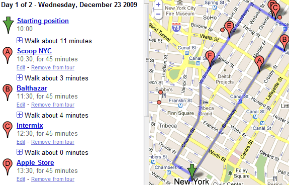
Google City Tours, the service that generates walking tours for important cities, has a new feature that lets you import custom maps. After logging to a Google Account, you can go to the importing page and select one of your maps.


The service would more useful if you could customize a tour by reordering sights and defining constraints. Other features that seems to be missing: saving tours, sharing and printing tours.

Google City Tours will probably become a feature of Google Maps that will help you find more about a city and plan your trips.

Wednesday, October 28, 2009

Google Maps Navigation for Android

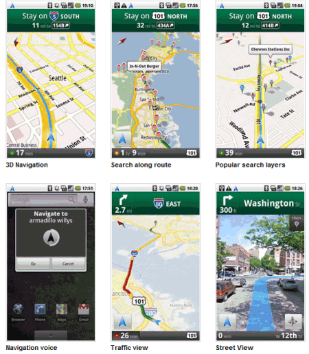
One of the most requested features for Google Maps Mobile was to add turn-by-turn navigation. In the past, this wasn't possible because of the licensing fees that had to be paid for each user of the navigation system. Now that Google no longer uses data from TeleAtlas in the US, turn-by-turn navigation can be added for free.

Google's blog announces that Google Maps Navigation will be available in Android 2.0. The first mobile phone that comes with Android 2.0 is Motorola Droid. "This new feature comes with everything you'd expect to find in a GPS navigation system, like 3D views, turn-by-turn voice guidance and automatic rerouting. But unlike most navigation systems, Google Maps Navigation was built from the ground up to take advantage of your phone's Internet connection." And unlike other navigation systems, it's free.

For now, Google Maps Navigation is only available for the US, but it will certainly be available in other countries when Google collects enough mapping data.


Companies that provide navigation solutions aren't afraid that they'll lose their customers. "There's a lot of content included in our applications that gets updated on an ongoing basis--and that costs money. Millions of customers use our service because of its reliability, ease of use and additional features. People are willing to pay a premium to have something work all the time on their phones," said a TeleNav spokesperson.

Monday, October 19, 2009

Google Map Maker Layer

If Google Maps doesn't offer high-quality maps for your country, you can improve them using Google Map Maker. "Google Map Maker allows you to create a map by adding or editing features such as roads, businesses, parks, schools and more. Using Google Map Maker tools, you can visually mark locations and add detailed information about them. Once you have submitted content, this information may be edited by other users or moderators. Your mapping contributions on Map Maker are eventually also made available on Google Maps," explains Google.

Google constantly updates Google Maps with data from Map Maker, but the changes aren't reflected immediately. To see the latest data from Google Map Maker, add this layer to Google Maps.


Google Map Maker lets you edit the maps for 174 countries because the maps licensed by Google aren't detailed enough.

Sunday, September 27, 2009

Google Street View's Partner Program

Google has a partner program for Street View. "Do you manage a unique property (pedestrian mall, amusement park, university campus, etc.) that users would like to visit in Street View? Through our Partner Program, you can now request Google to collect imagery of your location. Once the images are added to Street View, people all over the world will be able to virtually explore your property."

For now, the program is limited to properties that are interesting to Google's users. Some of the examples included in the FAQ: "zoos, parks, universities, amusement parks, outdoor marketplaces, stadiums, monuments, tourist destinations, and race tracks".

Here's a Street View tricycle at the Palace of Versailles:


... and another Street View trike at Stonehenge:


{ via Brian Ussery }

Friday, September 25, 2009

Google Maps Place Pages

When you perform a search in Google Maps and click on "more info" next to a search result, Google opens a new page that aggregates useful information about places and local businesses. Until now, Google showed an expanded bubble directly on the map.

The new Google Maps pages have user-friendly URLs like http://maps.google.com/places/fr/paris-city and they include a lot data: photos and videos from Panoramio and YouTube, user-generated maps, reviews, related web pages, information from Wikipedia, Street View imagery.


"We think Place Pages will make searching much easier (and hopefully more fun!) for our users, but we're also excited about what it means for business owners. By default, users looking for local businesses can easily view ratings for your business, reviews, related maps, find nearby transit options showing them how to get to you, and take a look at your business with a Street View preview - and it's all on one page," says Google LatLong blog.

While new Place Pages look nice, they have a big drawback: when you click on "more info" next to a search result, Google Maps opens a new page and you lose the context, so it's difficult to compare the results. To go back to the list of results, you need to use your browser's back button.